Embedded Files
Lyn Topinka, Columbia River Images: Larch Mountains, Washington and Oregon
Lyn Topinka, Columbia River Images: Larch Mountains, Washington and Oregon
No "Larch" in the Larch Mountains ...
No "Larch" in the Larch Mountains ...
Both Larch Mountain, Oregon, and Larch Mountain, Washington, are covered with Noble Fir, a tree first collected and named by David Douglas in 1825 in the high mountains near the Cascades of the Columbia River. The timber industry however referred to the Noble Fir as a "larch" to emphasize the good quality of wood (most firs are not good for lumber) resulting in the names of both mountains.
Larch Mountain, Oregon ...
Larch Mountain, Oregon ...
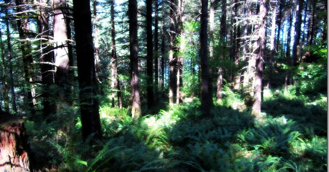
Larch Mountain, Oregon, is a 3,947-feet-high shield volcano of the Boring Lava Field, with the uppermost lookout area being called "Sherrard Point". Larch Mountain rises above Multnomah Falls (but is not visible from there) at approximately Columbia River Mile (RM) 136. There is a 6.8 mile U.S. Forest Service trail which connects the two. A good view of Larch Mountain, Oregon, can be had from the Tunnel Point Pullout on the west-bound lane of Interstate 84, just east of Portland, Oregon.
Boring Lava Shield Volcano ...
Boring Lava Shield Volcano ...
Oregon's Larch Mountain is a Boring Lava shield volcano. According to Evarts, et.al., (2009, GSA Field Guide 15):
Larch Mountain is a small shield volcano and one of the larger centers in the Boring Volcanic Field. Its flows are petrographically distinctive, containing phenocrysts and glomerocrysts of coars olivine ± augite in a plagioclase-microphyric groundmass. Chemically the flows are relatively uniform low-silica andesites. Conrey et.al. (1996) obtained a conventional K-Ar age of 1.53 ± 0.05 million years from this outcrop. Larch Mountain flows are magnetically reversed.
The road continues [to] Sherrard Point at the summit of Larch Mountain. Five Cascade stratovolcanoes (Rainier, St. Helens, Adams, Hood, and Jefferson) can be seen from that viewpoint, which sits atop a cirque carved into an andesite plug that fills the vent of Larch Mountain volcano.
Lyn Topinka, Columbia River Images: Larch Mountains, Washington and Oregonhttp://columbiariverimages.com/Regions/Places/larch_mountain.html
Larch Mountain Picnic Area
Larch Mountain Picnic Area
"According to the U.S. Forest Service's Columbia River Gorge National Scenic Area website (2020), located next to the Larch Mountain parking area, has vault toilets and ten picnic tables. It is the jumpoff point to Sherrard Point and hiking trails to Multnomah Falls or Oneonta."
"According to the U.S. Forest Service's Columbia River Gorge National Scenic Area website (2020), located next to the Larch Mountain parking area, has vault toilets and ten picnic tables. It is the jumpoff point to Sherrard Point and hiking trails to Multnomah Falls or Oneonta."
Lyn Topinka, Columbia River Images: Larch Mountains, Washington and Oregonhttp://columbiariverimages.com/Regions/Places/larch_mountain.html

View from the U.S. Forest Camp, Larch Mountain, Oregon.Penny Postcard, Real Photo, Divided Back, "Viw From U.S. Forest Camp, Larch Mt. Oregon.". Ransford PC.14. In the private collection of Lyn Topinka. http://columbiariverimages.com/PennyPostcards/Images/PC_larch_mountain_forest_camp.jpg
"At the top of Larch Mtn is a former campground, established soon after the road to the top was completed in 1939. If you head left from the parking lot on the Multnomah trail, you'll soon begin to see scattered remnants of the original camp spots -- some mossy picnic tables and some super-mossy barbecue pits. Sadly, in mid '09 the powers-that-be decided to chainsaw and remove some of the better relic picnic tables, but there are still some to see and lots of mossy BBQs to investigate. In a couple minutes along this trail you can take a right turn and go uphill to the old traffic-circle roundabout where the Forest Service has its lookout towers and buildings."
"At the top of Larch Mtn is a former campground, established soon after the road to the top was completed in 1939. If you head left from the parking lot on the Multnomah trail, you'll soon begin to see scattered remnants of the original camp spots -- some mossy picnic tables and some super-mossy barbecue pits. Sadly, in mid '09 the powers-that-be decided to chainsaw and remove some of the better relic picnic tables, but there are still some to see and lots of mossy BBQs to investigate. In a couple minutes along this trail you can take a right turn and go uphill to the old traffic-circle roundabout where the Forest Service has its lookout towers and buildings."
Cook, Gorge 238
Larch Mountain Lookout
Larch Mountain Lookout
"According to "firelookout.com" website (2014) there have been three lookouts on top of Larch Mountain, Oregon. The first was established in 1914 and was a platform and cab atop two 90-foot fir trees. A 90-foot steel tower replaced it in 1923 and in the 1940s a 100-foot treated lumber L-4 tower was built with a tourist observation deck below the cab. This structure was removed in 1976."
"According to "firelookout.com" website (2014) there have been three lookouts on top of Larch Mountain, Oregon. The first was established in 1914 and was a platform and cab atop two 90-foot fir trees. A 90-foot steel tower replaced it in 1923 and in the 1940s a 100-foot treated lumber L-4 tower was built with a tourist observation deck below the cab. This structure was removed in 1976."
Lyn Topinka, Columbia River Images: Larch Mountains, Washington and Oregonhttp://columbiariverimages.com/Regions/Places/larch_mountain.html
The trail up from Multnomah Falls reaches "the top at the abandoned lookout tower. A special cabin near the tower is provided for winter use by hikers and cross-country skiers seeking shelter from inclement weather." (Lowe and Lowe, 1969, 46)
The trail up from Multnomah Falls reaches "the top at the abandoned lookout tower. A special cabin near the tower is provided for winter use by hikers and cross-country skiers seeking shelter from inclement weather." (Lowe and Lowe, 1969, 46)
Sherrard Point
Sherrard Point
Lyn Topinka, Columbia River Images: Larch Mountains, Washington and Oregon
Lyn Topinka, Columbia River Images: Larch Mountains, Washington and Oregon
The U.S. Board of Geographic Names made "Sherrard Point" the official name for Larch Mountain's highpoint in 1946.
From Oregon Geographic Names (McArthur and McArthur, 2003):
From Oregon Geographic Names (McArthur and McArthur, 2003):
Sherrard Point was named in honor of Thomas H. Sherrard, who was associated with the USFS for more than 40 years. It comprises the viewpoint on the northeastern extremity of the summit ridge of Larch Mountain and is marked with a bronze plaque. During his tenure with the USFS, Sherrard served as supervisor of the Mount Hood National Forest from 1907 to 1934 and took a keen interest in the development of recreation facilities as well as assisting in the establishment of the Bull Run water preserve.
Lyn Topinka, Columbia River Images: Larch Mountains, Washington and Oregonhttp://columbiariverimages.com/Regions/Places/larch_mountain.html

Sherrard Point TrailLarch Mountain, Columbia River Gorge, Oregon. June 28, 2011

Camas, Washington from Sherrard PointLarch Mountain, Oregon. Taken June 19, 2004.Copyright © 2012 A. F. Litt, All Rights Reserved

Mt. Hood from Sherrard PointLarch Mountain. Columbia River Gorge, Oregon. October 6, 2010

Hood From Sherrard Point (2004)Larch Mountain, Columbia River Gorge, Oregon. June 19, 2004.Copyright © 2014 A. F. Litt, All Rights Reserved

Sherrard Point. Larch Mountain.Columbia River Gorge, Oregon. 2006.Copyright © 2012 A. F. Litt, All Rights Reserved

Sherrard Point. Larch Mountain.Columbia River Gorge, Oregon. 2006.Copyright © 2012 A. F. Litt, All Rights Reserved

Thomas H. Sherrard PlaqueLarch Mountain, Oregon. August 20, 2013
Larch Mountain "Crater"
Larch Mountain "Crater"
Lyn Topinka, Columbia River Images: Larch Mountains, Washington and Oregon
Lyn Topinka, Columbia River Images: Larch Mountains, Washington and Oregon
Oregon's Larch Mountain is a Boring Lava shield volcano. According to Evarts, et.al., (2009, GSA Field Guide 15):
Larch Mountain is a small shield volcano and one of the larger centers in the Boring Volcanic Field. Its flows are petrographically distinctive, containing phenocrysts and glomerocrysts of coars olivine ± augite in a plagioclase-microphyric groundmass. Chemically the flows are relatively uniform low-silica andesites. Conrey et.al. (1996) obtained a conventional K-Ar age of 1.53 ± 0.05 million years from this outcrop. Larch Mountain flows are magnetically reversed.
The road continues [to] Sherrard Point at the summit of Larch Mountain. Five Cascade stratovolcanoes (Rainier, St. Helens, Adams, Hood, and Jefferson) can be seen from that viewpoint, which sits atop a cirque carved into an andesite plug that fills the vent of Larch Mountain volcano.
Lyn Topinka, Columbia River Images: Larch Mountains, Washington and Oregonhttp://columbiariverimages.com/Regions/Places/larch_mountain.html

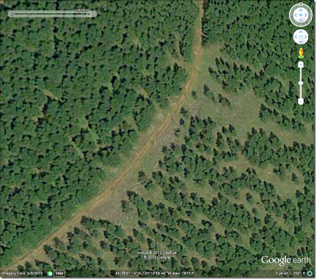
"Larch Mountain on Lidar. Glaciers? Well, maybe. Before seeing this, sure. But man, there's only one mountain around here that I know of that looks like that, and it sure wasn't shaped by glaciers."
Rubble: Larch Mountain on Lidar (September 21, 2013) https://rubble.blogspot.com/2013/09/larch-mountain-on-lidar.html
April 15, 2020
April 15, 2020
Many years ago I did a blog post looking at whether the Larch Mountain "Crater" was a glacial cirque, which is the current thought, or an actual volcanic crater. When I found the DOGAMI Lidar site, I posted the image above to my blog in reference to the earlier post, which I finally found and am excerpting below:
After hiking up to the “crater” at Bobs Mountain today (and looking for it’s missing apostrophe…), I thought I would look around for some more information about this mountain and the Boring Lava Fields in general. It is surprising how little is really known about them…
Still, after poking around up there today, I am leaning toward the crater being an erosional artifact, maybe a cirque from the Pleistocene and not an actual crater. It seems to me that a crater that size would not have survived on a volcano this old in this region. (See my earlier thoughts on this topic here… http://rubble.blogspot.com/2012/01/trail-report-bobs-mountain-washington.html)
It’s on the north side of the mountain and it reminds me of a smaller, lower, softer version of the cirque that is Larch Mountain’s “crater.”
John Eliot Allen, in his 1975 paper “Volcanoes of the Portland Area, Oregon," writes that Bobs Mountain may be “a relatively recent cinder cone” with a “crater outlined by an arcurate ridge, …lower on one side as the result of breaching by erosion.” This does describe what I saw up there today, though I would suggest the entire shallow depression was caused by erosion and just happens to bear the appearance of a typical, younger cinder cone’s crater.
Remember, even if this is one of the youngest of the Boring cones, we are still talking about a likely age of “50–130 ka,” which still leaves it vulnerable to late Pleistocene glaciation, as is assumed to have created the Larch Mountain crater. Recent, in this case, is not very recent.
Apparently, though, these ages are still vague, with more research needing to be done. Perhaps Bobs is a lot younger than we realize, though this does seem unlikely. But, as Allen writes, “more exact dating of the Boring Lava is urgently needed.” That was in 1975. I am not sure what has been done since.
While Bobs’ crater is on the north side, it may be a little low… In a different article, “Ice-Age glaciers and Lakes South of the Columbia River Gorge," Allen writes that he only assumes that a feature is evidence of glaciation in this area if “the landform is at an elevation above 3,000 ft, it is on an east or northeast slope, and it is one of a group of at least three similar nearby landforms located in similar topographic positions.” Later on he reiterates that glaciers in this region “rarely extended down below 3,000 ft in elevation.”
Since Bobs is significantly lower than 3,000 feet (2110 feet), I suppose I still have to allow for the possibility that Bobs is like Black Butte, near Sisters in central Oregon, an ancient volcano that appears to be a recent one. However, since the two peaks exist in such different locations, and since Bobs sits in a region that did experience significant erosion from local, alpine glaciers during the Pleistocene, and since it is unlikely that Bobs is less than 15,000 years old, I still have a hard time believing that erosion would not have been the principal cause of this feature…
Again, from Allen, discussing features such as the Larch Mountain cirques, “It is probable that most of [the glacial features on peaks across the Columbia from Bobs] described here were results of the last Vashon or Pinedale glaciation (Crandell, 1965), which culminated 15,000 years ago.”
Allen, 1975, Volcanoes of the Portland Area, Oregon: State of Oregon, Department of Geology and Mineral Industries, The ORE-BIN, v.37, no.9, September 1975 http://www.oregongeology.com/pubs/og/OBv37n09.pdf'
Allen, “Ice-Age glaciers and Lakes South of the Columbia River Gorge” OREGON GEOLOGY, VOLUME 51, NUMBER I, JANUARY 1989 http://www.oregongeology.com/sub/publications/OG/OGv51n01.pdf
Rubble: More fun with Boring Lava & the Catlin Gabel Lava Tube System in West Portlandhttps://rubble.blogspot.com/2012/09/more-fun-with-boring-lava-catlin-gabel.html
Links
Links
Columbia River Images: Larch Mountains, Washington and Oregon
Columbia River Images: Larch Mountains, Washington and Oregon
Includes ... Larch Mountain ... Sherrard Point ... Columbia River Valley ... Yacolt Burn 1902 ...
OregonHikers.org
OregonHikers.org
Larch Summit before all that cement was poured on it
http://www.portlandhikers.org/forum/viewtopic.php?f=30&t=14106
Heavy metal on Larch Mountain 2.22.2015
http://www.oregonhikers.org/forum/viewtopic.php?f=10&t=21149
2010.04.17 around Larch Mountain (April 21st, 2010)


CLICK HERE to continue exploring the highway
CLICK HERE to continue exploring the highway
Page updated
Google Sites
Report abuse