Embedded Files

Explore Tecate Mexico
Explore Tecate Mexico
May 3rd and 4th 2014

Dirt Bike Riding from Rancho Santa Veronicas
Explore Tecate Mexico! Come ride for the day, or come and ride for both days. We are staging out of the Hacienda Santa Veronica. Saturday will be a full day ride, Sunday will be a half day ride. I will have tracks available for your GPS. Plan on crossing the border at Tecate Rd (188) off the 94. The ride will be tailored to Dual Sport sized motorcycles, although you do not need a plated bike to do this ride. Bring a full gas can, as there is no gas there. If you leave your vehicle in the US, let me know so I can plan for your gas needs. Please book your room at the The Rancho Santa Veronica if you plan to spend Friday or Saturday Night(s). You will need a good electric heater and a sleeping bag, the rooms can be really cold. The food at the restaurant is excellent, the staff is great, the rooms are clean. Cost is $10.00 per person, and will include a cold beer or soda (sorry no refunds). We will meet at the restaurant Friday night at 6pm, and Saturday Morning at 8am.
Signup to Join this ride on the Meetup Site
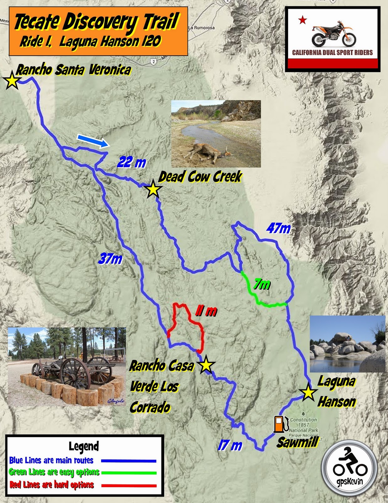

View the ride in Google maps below
OK since many of you might like to study more detail about the ride, below are the ride maps.
I put these ride maps on the web page because I know a few of you love looking at the ride detail and dreaming about the ride. At first glance these maps do not look so impressive, but they are way cool. If you click the Earth or Satellite tab and start zooming in, you can see the ride in incredible detail. I have spent a ton of hours sorting through the details of the ride for each day, so for those of you that enjoy this sort of thing, well enjoy!
Legend:
The Red lines are Harder routes
The Blue lines are main routes
The Green lines are easy options
Note: In the Download window, from the file menu, select FIle:Download. You may get a "can't scan for viruses" warning, select Download Anyway.
In the download you will get a Zipped Folder that contains:, Maps for Printing, Garmin Maps( contains the file for installing the custom ride maps into your gps) and a Tecate Discovery Trail All file containing tracklogs.
To install your Custom Garmin Ride Map into your GPS, you will first need to determine if you have a "New Style" or "Old Style" GPS unit. These each require different files. From the list below decide which type you have:
Old Style GPS:
Garmin 60s, 60csx, all 60s
Garmin 76, 76csx, all 76s
Etrex legend, vista,
Older Nuvi's, too many to list:
New Style GPS:
Etrex, 10, 20, 30s
gpsmap78
Nivi, 20, 30
Get a blank SD card, and open the Folder named "Garmin Maps", next open the correct folder based on your GPS type "New Style" or "Old Style" and copy the complete folder inside "garmin" to the sd card. Then just put the card into your gps and the map should be there when you turn your gps on. You will need to select the map that you wish to ride.
To print paper maps for the ride, open the folder "Maps for Printing" and select and print the maps.
FAQ:
Q: What do I do if my GPS is not listed above
A: There are 100s of gps's from garmin so there are too many to list, So ask yourself is my gps Newer or Older? Try that file type fist in your gps. If your gps does not have the ability to turn ON and OFF the different maps choices then you probably guessed wrong. So then try the other type.
Return to California Dual Sport Riders Home
Go to the Meetup Home page
Page updated
Google Sites
Report abuse