Embedded Files
Floodplain management
Floodplain management
The "fok" systems turned waters of the destroying Hungarian floods into the source of life.
A 'fok'(in Hungarian) is a break-through, an opening of the bank. It may be natural or artificial. The word fok means a gap, a channel at right angel to the river.
Water is the blood of the land. There is 500 mm average, 400 mm minimum rainfall on the Hungarian Plain in a year. This modest amount could support just a grassland. However, in the Middle Ages the entire plain was covered with dense forests. These forests were watered by a network of the rivers, creeks, brooks and ponds. Their water come from the Carpathians, but its circulation could work for it was supported by the „fok” system.
The logic of the fok system
The logic of the fok system
Natural river-banks are deposited from the debris of the rivers. When a high flood comes, it falls down from its banks to the deep parts of the floodplain, and the much of its water stays there forming wet areas, where often marches are developed.
The "FOK" systems turned waters of the floods into the source of life. A fok is a break-through, an opening of the bank. It may be natural or artificial. The word fok means a gap, a channel at right angel to the river. By the flood, the fok let the water of the river to enter onto the neighbouring plains, and later by the ebbing the fok leads back the water to the river, as the floowing sketch shows:
Sketch of the fok system
Sketch of the fok system
Further informations
Further informations
A more detailed and critical summary of Zoltán Fodor
Andrásfalvy B. 1973: A Sárköz és a környező Duna-menti területek ősi ártéri gazdálkodása (The ancient floodplain management of Sárköz and the surrounding territories by the Duna.)
Molnár Sándor: Floodplain management demostrated through two sampling sites
(Hungarian version)
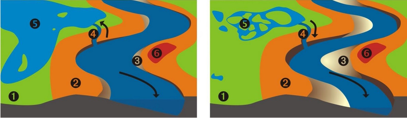
1: floodplain, 2: natural bank, 3: belt-cay, 4: fok, 5: pond 6: village.
By Molnár Sándor,2010
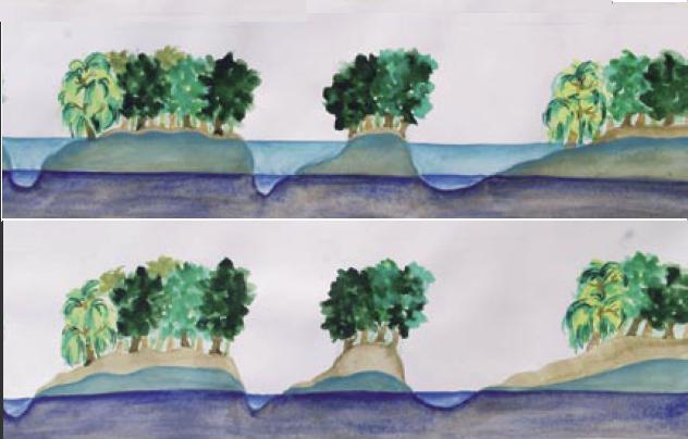
On the picture below, you can see the the foks at the village Tímár as they led the water through the banks of the river Tisza. A very important feature of the foks is the upward-filling, that is, the main foks lead the water upwards to the floodplain, so it fills the fish ponds and the meadows more slowly and less destroying than an easy downward running flood. (See the wonderful shape of the ponds, how many egdes they have.)
The fok system by village Tímár
The fok system by village Tímár

The forms and sizes are varied, but their sill level were
always +4-5 m above the zero level of the river.
The benefits of the fok system
The benefits of the fok system
Moderating the scale and the velocity of the changes of the riverbed. Less sediment enter to the floodplain, and on the other side, the moving water hinders the water plants to clog the water ways.
The upward-filling allows to lead back the water into the river.
Balance of the water regime: The foks decrease the height of the flood, and the continuously returning water rises the level of the low water in the river.
Positive effect on the mezoclimate: the wet environment tempers the extremities of the continental weather.
At the ebbing, the back-flow averts the drowning the plant, which can not survive too much time under water.
The short floods fertilize the forests, the fruits and the meadows.
Larger amount of water is stored on the floodplain. It feeds the floodplain forest with water, makes them to live. In return, the so called waterhills under the soaked forest seep back the water slowly to the creek. They also transpire a lot, which falls back to the plain and to their estuary as rain.
Waterhills of the floodplain
Waterhills of the floodplain
Beside the traditional oak and willow forest, there were floodplain fruit-jungles with surprisingly many local fruit species. At the region of Sárköz 45-50 varieties of apples, 30-40 pears, 20 plums, 5-6 cherry and 4-5 sour-cherry were cultivated. (I could not mention more the ten varieties of apple…)
Fish, fish and fish. It used to be said: The river Tisza consisted of 2 parts water and one part fish. It was nearly true. The fish found good spawning and feed ground on the floodplain. At the beginning of the ebbing they returned to the river. The fishers had rich catch at the exits, but many fish got into the river, and this made an abundant fishing also in the Tisza itself. Even after one or two drought years there was a good fish-stock in the river, just a longer dry period made lager decreasing. However, after the collapse of the fok systems, the fishing in the river became insignificant.
Brief history
Brief history
We do not know when the first foks were built. There are remnants of water works from the 3rd century. For the 14th century a network of villages were developed with ponds and water ways. This system covered the water-flooded territory of the Hungarian Plain. Look at the picture below ! The light blue parts are the temporary, the darker blue parts are the permanently water covered lands of the plain. Near the two third of the basin was floodplain. The density of the settlements is interesting, and it show, how many people were supported by this wetland.
Water covered parts of the Hungarian Plain
Water covered parts of the Hungarian Plain

In the 15th century the Hungarian Plain became a war zone. Burning villages, murder, rake and slave-hunting. Many villages disappeared, people went away to country towns, or hid into the marches. The fok system collapsed, as there were no communities to manage them. Many times the foks were clogged intently to prevent the transportation on them, and to extent the marches as refuges. A downward spiral was developed. As result a large march-land developed.
At the end of the war the population began to rise, but at first the new Habsburg governing did not admit the former common law of free fishing for personal needs. The free fishing and the common maintenance of the waterworks were the economic base of the fok system. Then after Napoleon wars, a great grain-conjuncture came. You can image that age, as grain was the fuel, as the transport was animal powered, and the great river was the highways of the Habsburg Empire. The fertile south part of the Great Plain, the “South Country” was colonized and was utilized for grain production. The product was loaded onto ships, and it was hauled upward on the river Duna to north by horses and cattles. However, the riverbank was cut by the hundreds of foks crossing the moving of the hauling animals.
So the government ordered to bury all the foks of river Duna. The villagers protested as the burring the foks ruined their sustainment but they were not listened neither by the government nor by their landlords. The landlords wanted to profit form the conjuncture, they wanter more land. They could not take away the law protected serf-lands, so they tried to fulfill their needs for ploughland from the common lands of the villages, as the forests and the flood plains. The forest was cut first, and then the marches and flood plains became the next target. The frequent flood were obstacle of the grain production, so in 1840 the great river regulation begun. The greed of landowners met the ignorance of the strange experts. (Have ever you heard some similar stories?) Engineers, who studied at German and Austrian universities, organized the regulation work knowing anything about neither the previous water networks nor the very rhapsodic Hungarian water regime.
Their very first step of regulation of river Tisza was closing its foks too. Later they cut the curve of the rivers, dug new river bed, and place the river between narrow banks. And we could see the effect of all of these efforts pretty soon: in 1879 came the first great flood, and it swept away the town of Szeged (it was the 2nd largest Hungarian town that time; the flood destroyed the 90% of the buildings and killed 200 people).
Our problems are the same since then: Heigh, dangerous floods and severe droughts, often in the same year.
Today
Today
The great flood of Szeged in 1879 was 850 cm high . The last record high flood wave was 1040 cm at Szeged in 2004. The town was protected, but it makes clear, that it is just a question of time when the next devastating floods come. These don't just threaten towns, but even the nation's capital, Budapest. The most promising is the renewal of the fok system.
Page updated
Google Sites
Report abuse